Thursday, April 22, 2010

Meadow Loop/Telegraph Trail

Distance: 5 miles
Altitude Gained:  880 ft
High Point:  7480 ft


welcome to life
flora, and our gratitude
for painting the day

The Meadow Loop and the Telegraph Trail are two more trail options in the extensive Telegraph system.  John Peel lumped them together in the 4th edition as a suggested hike of their own; we dig.  It's high point is near the top of the next ridge over when you look east from Raider.  You have endless options when you hike around in these trails, but we find this suggestion a good route for discovery when you only have a few hours but you want to climb a little to great views. 


We had a glorous hike.  The spring is coming alive, and so are we.  We absolutely love this planet we're on.  Happy Earth Day!


We think Maggie and Barb Casey feel the same way.  They were on mountain bikes of course, as was every other person we passed on trail.  This athleticism impresses us, naturally.  But we are happy to be hikers.  Hiking, one sees and contemplates more of the treasures the trail has to offer.


up on telegraph
dead trees tell ancient secrets
of Earth's yesterday


These dead trees left standing in the forest to decay naturally are called snags, and we love em'.  We are impressed not only with their astounding aesthetic but also because these seemingly lifeless trees support hundreds of different species in the forest ecosystem!  Mammals, birds, reptiles and insects shack-up together in the beautiful hardwood condos.  Plus, the dead wood attracts mosses, fungi and lichens which serve as food to these tenants while they aid in decomposition, returning vital nutrients to the soil. Ahhhh, the cycle of life!
Our botanical friends are alive and blooming; the smell of Mountain Sagebrush tickled our nose, new Apricot blossoms are everywhere and the Scarlet (or Indian) Paintbrush threw us bursts of vibrant red.  


 We saw some more scat, same as before but older: very hairy, curly-like, tapered ends.  This is the second time in Horse Gulch that we have seen evidence of our feline friend, the Mountain Lion.  Because pumas are incredibly solitary and territorial, we believe we are "tracking" the same cat; the home range of a male is 30-100 square miles and excludes other male mountain lions.  In that case, we feel we're forming a small bond :)  What shall we name him?
    

Our highlight this hike: the Western Chorus Frog (Pseudacris triseriata)
We think this symphony says it all...


Sunday, April 18, 2010

Raider Ridge

Distance:  4.6 miles
Altitude Gained:  880 ft.
High Point:  7480 ft.


north, south, east, and west
circumspectacular views
of where we're livin'


Raider Ridge is our neighborhood mountain; the trailhead is 9 blocks from our house.  As FLC alumni, it holds a special place in our hearts as our campus basically sits in its lap.  It affords some of the best views of our perfect little river valley home.  As you walk along the top of the ridge (also a hogsback, geologically speaking), the perspective changes, revealing how the Animas River left its print in the Earth's surface.  Contrary to popular misconception, the Fort Lewis campus is not a mesa, but a river terrace.  According to Encyclopedia Brittanica, a river terrace is a "bench or step that extends along the side of a valley and represents a former level of the valley floor."  
  

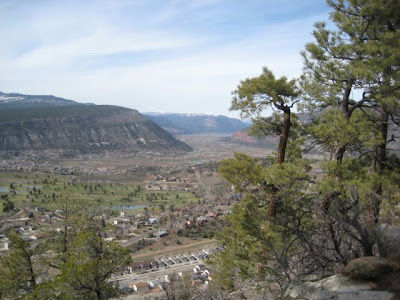
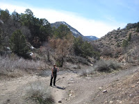
Raider Ridge is part of the Telegraph Trail system, a gigantic series of lovely trails east of downtown, which from what we can tell, must be mountain bike heaven.  We enjoy them plenty on our two feet.  At last publication of Hiking Trails, there was no trail connecting back from the north end of the ridge; to get down from the "extended ridge" you had to turn around and go back or bushwhack back down to Horse Gulch.  But thanks to a compromise in 2009 between the city, Trails 2000, and property owner and lifetime Durangoan Jake Dalla, you can now make a full loop. (more


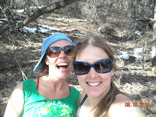
The main trailhead is located on 9th Ave. and East 3rd St.   Although technically prohibited, many FLC students charge up the side of it.  It is difficult not to do so as the ridge feels as if were part of the campus.  The mountain is named for the college's former mascot, the "Raiders" (Pixler notes that at one time the students maintained a giant "R" on the side of it).  We stumbled upon some FLC students who couldn't resist the temptation to raid the ridge; we found them sunning themselves on the black dirt like lizards. 


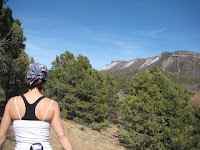
Near the south end, Raider Ridge features a sort of sandstone living room, a collaborative effort between nature and man.  You can rest your bones after the climb in a number of different chairs and loveseats.  We took a moment to consult Pixler and Peel.


The critters in Horse Gulch are dewinterizing in the warm April sun; we were lucky enough to spot many plateau lizards, dance with a California Tortoiseshell, hear the threatening rattle of a pit viper, and track a deadly mountain lion!  


The reptiles joined the students out in the sun for some solar heating. The lizards were darting here-and-there under the brush throughout the whole hike.  We got two pictures of the lil' Sagebrush lizard (Sceloporus graciosus), who is surprisingly photogenic. 


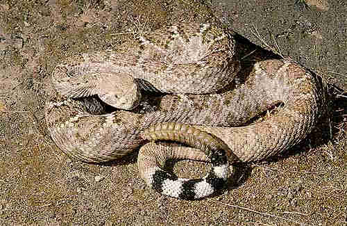
On our descent, as we joyously bounded down the ridge, we were stopped abruptly in our tracks by the sound of a rattlesnake.  Using our better judgement, we didn't stop for a picture.  However, I can deduce that the ominous rattle came from the Western Rattlesnake (Crotalus viridis) because it is one of only two rattlers found in Colorado; the Massasauga is limited to the eastern grassy plains and the Western is found virtually everywhere in the state.  These guys have been hibernating all winter in their snake dens and they sun themselves for several days after waking.  Needless to say, these snakes are hungry and easily agitated after a long winter...no wonder we got a warning rattle!  (photo source: http://www.venomousreptiles.org/)


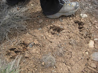
Ironically,the species highlight of Raider Ridge was not seen, and we were very grateful for the non-sighting! First, we came across some very hairy scat, which clearly belonged to a cat because of the tapered ends. Then, about 20 feet down the trail we stumbled upon some large prints in the mud matching those of a mountain lion (Puma concolor):  round, lobed heel pad, toes evenly spread, and lacking claw marks.  This is prime real estate for a mountain lion, as they prefer to stalk their prey from trees and high cliffs. These predators are primarily nocturnal and entirely carniverous, preying on hares, raccoons, skunks and deer.  They are excellent climbers, extraordinary leapers and will even swim if necessary!    


As we left, a beautiful butterfly flittered and fluttered around our heads until we stopped to let it land at our feet.  Unfortunately, our camera's battery had already died and we were unable to get a picture.  But we were able to get a great look at this beauty, and we are nearly positive that it was a California Tortoiseshell (Nymphalis californica) or another close relative.  Its piano-key wings were distinct and memorable.  We borrowed this photo from the Internet.   

c. John Sterling (source: http://www.cal.net/)


We adore and HIGHLY recommend Raider Ridge.  It is good for a quickish hike or a longer, more leisurely one.  A breathtaking place to spend time.  We'll be back in the area soon to check out more of the Telegraph system and to keep on tracking our puma :).  
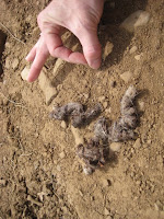
 

Friday, April 9, 2010

Animas (City) Mountain: Part 1

Distance: this time, just a fraction, maybe a mile?
Altitude Gained: 900 ft?  1000ft?


O bluebird! O spring!
O friendly city mountain!
O my soul's own peace! 


Today's hike was just a preview of Animas as the majority of the mountain is still closed to human traffic.  But after Hogsback we needed something a little friendlier.  And we love this mountain, always have. 


Animas Mountain or Animas City Mountain?  Which is the true name of Durango's most beloved mountain?  Why can't it just be both?  John Peel himself wrote an article recently about this very topic.  We tend to just call it Animas, actually.  "It's a beautiful day.  Let's go hike up Animas!" 

The main trailhead is at 32nd and W. 4th Ave, but we like to catch an alternate trail through some private property before the water tower.  The second we got on the trail today, it was like we were home. 


There is something about the energy on this trail that soothes the soul.  It is as calming as it is invigorating.  We are always saying that Animas Mountain is the friendliest mountain around.  It just sort of takes you by the hand, you know.  You can leave your troubles back in the city, and Animas will always help you remember what life is really about.


It didn't hurt that it was sixtysomething degrees outside.Or that the birds were engaged in a full-on spring symphony.  I guess you could say it what one of those Zip-A-Dee-Doo-Dah days.  And although the bluebird didn't land directly on our shoulders, it may as well have for all the wonderful feelings comin' our way. 

The mountain bluebirds (Sialia currucoides) were too busy enjoying the spring day to even notice us.  The pair we watched was busy building a nest to house their new babies that will be coming soon. Actually these birds prefer to nest in pre-existing cavities or man-made nest boxes; usually the female builds up the nest and the male pretends to help.


We didn't see any of the majestic elk (cervus elaphus) for whom the mountain is closed, but they had been around recently.  The BLM closes Animas Mountain some years to create a safe winter habitat for elk and deer when the climes of the higher altitudes get too extreme (more).  The elk are an interesting bunch.  According to the field guide, they are "gregarious animals."  Apparently, no other mammal male gets more action than the elk bull; one bull will mate with the entire harem of cows.  Maybe they should seek habitat in Utah?

The rising temperatures are surely sending the elk back into higher country, leaving Animas Mountain for we humans to enjoy for the summer.  The rest of the trail opens in a week; stay tuned for the completion of this lovely mountain!


enchanted forest!


Wednesday, April 7, 2010

Hogsback

Distance:  2 miles (round trip)
Altitude Gained:  843 feet
High Point:  7484 feet


a quick intense push
up a steep slippery slope
careful! the shale slides!


Hogsback, named for the geological feature that it is, looks over Durango from the west side of town.  It is the highest point in Durango Mountain Park, a collection of trails that is a favorite among runners, hikers, and particularly mountain bikers.  We have been itching to gain some actual altitude, and Hogsback has been staring at us from across the valley, looking drier every day.  We knew we may encounter some snow, but we just couldn't stand it anymore.  So we walked out of the back door of our downtown house, walked across the valley through the Town Plaza parking lot, crossed the river and walked up El Paso St. into the westside 'hood to Leyden St, where you catch the trailhead right from town.  This is one of the coolest things that Hogsback has going for it:  its convenience from town.  As noted in the 4th edition of Hiking Trails, you can do it on a long lunch break.


We sure did pick a cold windy day to do this hike. It was 34 degrees as we passed through town, but the sun was shining and our spirits were high.  As we began our ascent, clouds were starting to rise behind the mountain to the west.  At the top, we were met by snow flurries and whipping winds.  We couldn't even enjoy the large sandstone rest stop because the cold was painful; we had to hide underneath it away from the wind.  


We have to be honest.  We don't love this mountain, never have.  Its burley ascent has never failed to invoke fear in either one of us.  Pixler used to rate it as "easy, except last 200 yards."  John Peel has revised it to read "moderate, due to steep finish."  We agree with the change.  This mountain is only easy for the first ten minutes.  You couldn't rate it as difficult because it is just too short to really be difficult, but make no mistake:  it's a serious climb.  It is steep.  Some of its steepest spots are nothing but open shale with nary a bush to grab onto.  And the shale is eroding right under your very feet.  We sometimes get vertigo on the way up when we allow our peripheral vision to mess with us. 


Not everyone feels this way about Hogsback.  We passed people and dogs on the trail today who seemed undaunted by this eroding ridge.  We ran into Meghan Wells (wife of Olympic mountain biker Todd) on the way home, and she said it's probably her favorite hike.  She likes it for its exercise value and quick up-and-down convenience.  It is a butt burner without a doubt.  But we tend to like hikes with a little more enchanted forest and a little less slippery slope.  We can't believe that Michael Hurst (and Todd Wells and many other hard cores for that matter) ride their bikes down this hogsback.  Props to them.  We are happy to just get down on our two feet.

facing west toward Perins Peak

Nevertheless, Hogsback gave us what we needed today:  a lot of adrenaline, a little bit of altitude, and views from above of the valley we love.  Even though it scares us some, we will be back when the weather is better. 

facing east toward town


O Wow, the Red-tailed Hawk (Buteo jamaicensis) may be common, but it never fails to impress.  We were lucky enough to be above a male who was soaring or "kiting" the wind, looking for food below; so the characteristic reddish tail feathers were visible and vibrant to us. These birds are carniverous and have extremely keen eyes that can spot a mouse up to a mile away!!  They are also monogamous and won't take another mate until death, which makes me wonder if humans could learn a thing or two from our fine feathered friends. And yes, Kevin, these birds have large talons.


(photo and video source: www.allaboutbirds.org)